More wonderful views from the top of
Salts Mill chimney. These are perhaps of more particular interest to those who live locally... Like me, you may be able to spot your own house!
(Photos will enlarge if you click them, I think.)
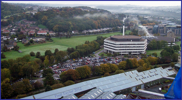
5⇧ We start with the picture above, looking north from the chimney, beyond the New Mill and the river hidden by trees, and over to Baildon's Coach Road. The hamlet of
Baildon Green is up to the top right with the main village of Baildon on the hill. To the left is Hope Hill and the woods of Shipley Glen. By the way, as I'm sure you'll realise, the turquoise pole in the foreground is one of the copper lightning conductors attached to the Mill chimney.
6⇧ Swinging round clockwise a little, to the north-east, the foreground shows some warehousing attached to Salts Mill. The modern hexagonal building is the banking centre for Britain's tax authorities (HMRC), bounded by the canal to the front and the river to the back, where the lines of trees are. Behind that on the right is the
Victoria Mills apartments complex.
7⇧ A little further clockwise, the office block on the left is the Waterfront Centre, which now houses, among other things,
Macmillan Cancer Support's new fund-raising centre. Behind that is the new white-painted
orthodontics factory. You can see the Leeds-Liverpool canal slicing through on the left and the railway on the right. In the middle distance is Shipley town centre - you can perhaps make out the
modernist clock-tower on the right. The hill in the background rises up to the areas known as Windhill and Wrose.
8⇧ Swinging clockwise again and looking south-east, Shipley's clock tower is now in the top left. The church sitting prominently on the hill is
St Paul's. Behind the church, in the fog-filled dip on the horizon, is the city of Bradford. Imagine the miasma that used to hang over it in Victorian times! No wonder Sir Titus Salt moved his business out to Saltaire. You can see Saltaire Road running through the middle of the photo. The large building in the mid-right is
Wycliffe Primary School.
9⇧ Moving clockwise a little further and now looking south, the terraced housing at the bottom of the photo is part of Saltaire. It was built later than the rest of the village, around the turn of the 19-20th century, when the Salts estate sold off some land after the great
Jubilee Exhibition. At one time the terraced housing extended down Saltaire Road on both sides, but some of it was demolished and the more
modern flats in the middle of the photo were built. You can't really tell from this perspective, but the land on this photo rises steeply from the bottom to the top. The area of green on the far right (behind the fire station, which you can't quite see) was once a quarry. Right on the skyline, about a third of the way in from the left, you may be able to see a chimney which I believe is Bradford's other great
Victorian mill, Listers.
[To complete the 360º panorama, look back at yesterday's photos in the order, 4, 3, 2. ]
I'm sure you'll agree that these photos make a wonderful record of Saltaire and its surroundings in 2012. I am delighted to have been able to share them here. Once again, my huge thanks to Paul Taylor whose idea this was, and to the unnamed photographer, who bravely took a camera to the top of Salts Mill chimney to capture the views for posterity. It looks like it was a typically damp, misty autumn day when they were taken, so it was very good of him to brave the drizzle.


