I HAVE CLOSED DOWN THIS BLOG. Please click the photo above to be REDIRECTED TO MY NEW (continuation) BLOG.
Showing posts with label floods. Show all posts

Thursday, 13 February 2020

Flood waters


More photos from the flooding on Sunday. In 2015, the water surrounded the bench in my photo above and inundated the car park and mill buildings on the far bank. I think, apart from the basement, they were spared this time. Further out, beyond the park, the flood plain was doing its best to hold the water. This is the site of the new nature reserve, so one hopes nature can adapt to the boggy conditions, and wild flowers will still bloom in the meadow in the summer.


The picture below shows, in the far distance, the football pitches between the river and the canal. The river's normal course is between the blue stands and the line of trees in the middle distance. On Sunday, you really couldn't tell the difference between this side of the trees, normally grassland, and the river itself. The new bench and newly planted trees seemed to be holding firm, thankfully. It would be a sad shame if all the work volunteers have put in to the nature reserve were to go to waste.


Things were even more dramatic upstream by Hirst Weir and the rowing club. You can see the clubhouse through the trees, impossible to get to. The normally minor trickle of Loadpit Beck comes down, from the right, to meet the river here. There is a little footbridge that crosses it. You can just see its handrail in the trees, in the midst of the swirling mass of water. There are some houses, just behind where I stood to take this photo. They were above the water line but I imagine it was making the residents rather nervous.


Wednesday, 12 February 2020

Storm Ciara


Storm Ciara dumped a whole load of torrential rain, along with gale force winds, on the UK on Saturday night through to Sunday. The towns in the Calder valley were again badly affected by flooding, despite considerable sums being spent on flood defences since the epic disaster of December 2015.

In Saltaire, the floods weren't as bad as 2015. Compare my picture below with the one HERE, taken in 2015 from about the same spot. This time the water didn't reach the Half Moon Café and the alpaca statue. In 2015 the alpacas were standing in water up to their necks.


It's quite scary though, watching the force of so much water. It can do a lot of damage. They were busy putting up flood barriers to protect The Boathouse Inn, which was badly damaged in 2015. When I was there on Sunday, the water had not quite reached the level of the terrace. In theory the river level was supposed to peak about the time I was there but I haven't had chance to go back to see if it got worse or better.


I'm not sure the dog in the picture below can understand why he can't walk along his usual route around Roberts Park. It looked as though the cricket pitch playing surface was spared. I'm sure the greenkeepers will be relieved.


Wednesday, 28 December 2016

The fence


You may recall that this area suffered terrible flooding a year ago on Boxing Day 2015. (See here) There are still a few homes and businesses struggling to get back up and running but, by and large, everything has recovered, thanks to enormous efforts from local communities. The Bingley allotments where my friend has a plot were badly damaged. I had the idea to make and sell greetings cards (see here for the story) to raise funds to help them replace some of the fencing and sheds. I am proud to say that we raised over £1000 from the project. It has contributed to the sparkling new metal fence, in my photo, which separates the allotments from the public right of way that goes into Myrtle Park. A large section of the old Victorian railings was swept away by the floodwater.

Wednesday, 30 March 2016

Hirst Weir


This familiar shot of Hirst Weir is less familiar since the Boxing day floods. The weir has been substantially rearranged, with stones strewn over a wide area. It has not stopped the fishermen, two of whom were right in the river below the weir, in their waders. The river looks benign again now and some repair work appears to have been done to the bank on this side but in December it must have been quite terrifying for those living in the apartments in the old mill, the lower floors of which were badly affected by the floodwater.  There is a wooden deck (around that conservatory) that is all ripped up even now.

Click the Hirst Weir label below to see what the area has looked like when I have taken previous photos here.

Wednesday, 16 March 2016

Thackley and Esholt 3


Oh dear... I had forgotten that a walk along the riverbank might not be so pleasant at the moment. The trees and banks are still strewn with debris left by the Boxing Day floods and in parts the path itself is barely negotiable. There have been many volunteer 'clean-up' days but it doesn't look like they have got this far yet. Anyway, it would be pretty difficult and not very safe to collect up the plastic and waste that is lodged in the branches overhanging the still fast-flowing river.  Here is someone's mattress - perhaps out of a caravan or something.


A trailer from a farm or industrial unit is lodged against the bridge.


Further down there are tyres and a huge metal container, swept several miles downstream from the Baildon Bridge area. I also saw a large wooden pallet and a car hubcap way up high in a tree, and plastic plant pots everywhere, perhaps from my friend's allotments!

A little further on there is a long section of collapsed stone wall that will keep a dry-stone-waller busy all summer. And oh, the mud everywhere!


Sunday, 17 January 2016

Hebden rising


I travelled over to Hebden Bridge (where my daughter lives) on Saturday to support a fundraising event after the Boxing Day floods devastated the town. The fundraiser had all sorts of brilliant activities for children: face-painting and dressing up as pirates, a toddler 'rave' (disco!), lots of food and lots of music of all kinds for all ages. Great fun.

It is shocking to see the extent of the destruction in the valley. There is hardly a business in the centre of the town that is still able to function, let alone the countless families forced out of their homes. It is, however, heartening to see the community spirit and the determination to get back to normal. Some of the cafés are open and serving food and drinks, even though you can see the damp on the walls and the damage that will have to be put right. Some of the shops are operating as 'pop-ups', selling salvaged stock, or as market stalls, or online.

You can see in the pictures above that many of the shops have tracks for inserting flood barriers across the door. They had been designed to take care of the extent of flooding in the past - but see here for a photo showing the level of the Boxing Day floods along the main street. The barriers and sandbags were simply overwhelmed. Even some premises that had been 'tanked' (sealed) to five feet high were inundated.

Friday, 15 January 2016

I'll go no more a roving...


I suppose I shouldn't have been surprised to find that my favourite little footbridge was washed away in the floods....


Tuesday, 12 January 2016

Après le deluge 3


Although the rain has lessened off to a fine drizzle interspersed with heavier showers it is still incredibly wet - and very mild too, so that spring bulbs are coming up and the willows have a fine sheen of spring colour already. It looks like we are about to be shocked by a colder spell starting this week though...

Not to be deterred by the weather, I set off along the canal towards the aqueduct, intending to walk back on the riverbank, and just interested to see what damage the recent floods did along that stretch. The river, as you can see above, is still very full indeed (those trees are normally on the bank) and the current is very strong. The poor ducks were being taken on the equivalent of a rollercoaster ride if they ventured into the flow.

To see more or less the same stretch of river in February 2014, click here. I thought it was full then!


There are a lot of trees down. I can't remember it being really windy but maybe the force of the water brought down some vulnerable ones. This one blocked the path and I had to climb over it.


There are new waterfalls coursing down the hillsides.


In parts, the riverside path is all but washed away.


And at this point I gave up and retraced my steps, not being inclined to risk trying to balance on those wobbly little stones without anything to steady me. The current, even in this small side stream, is strong and the water deeper than it looks. With my camera and iPhone, I didn't want to risk dropping several hundred £s worth of equipment in the water! I should have worn wellies but I had my hiking shoes on and they are not fully waterproof.


This is where the Aire flows under the canal aqueduct. There is a huge amount of debris clogging up the watercourse and I don't suppose that makes things any better. Some bridges in some areas have been very badly damaged by the force of water and debris hitting up against them.

Monday, 11 January 2016

Après le deluge 2


I'm not sure that I have ever shown this view of these houses on Hirst Mill Crescent before. It's an interesting old row of very disparate cottages and larger houses, with an old mill converted into flats right at the bottom of the lane. The hamlet is tucked in between Hirst lock on the canal, with access over the swing bridge, and on the other side of the mill the River Aire goes hurtling past over the weir. (See here for a view from the other side). Some of the houses date back to the 1860s, when there was a farm on the opposite bank of the canal and a lock-keepers cottage on this side. There has been a mill at the end of the lane since 1740, at first a corn mill, later converted to paper making. The mill and hamlet were bought by Sir Titus Salt in 1872 and let to tenants. It was used by a firm who washed industrial cloths (their sign is still visible on the brickwork), then a mattress maker and finally a textile combing firm. It closed in 1968 and was made into flats in 1970.

With so much water surrounding them, it is hardly surprising that some of these properties were flooded in the deluge on Boxing Day. Skips full of soggy furniture and ruined possessions are an all-too-common sight round here at the moment. Heartbreaking.


Tuesday, 29 December 2015

Après le deluge


Three days after the floods, the waters are receding, leaving just mud and debris behind.


You can see how high the water level reached, from the tideline of twigs and dirt left on the slopes. The compressed gravel path beside the weir was completely swept away.


The Boathouse left high, if not dry, ready for the mopping out to begin. Unfortunately another storm is blowing in, promising more heavy rain, so any clear up may be a bit premature.


The Salts Sports Club has been badly affected. These were the tennis courts and below, the main drive.


The once pristine bowling green is a swamp of mud.


These houses narrowly avoided inundation; you can see the line of debris showing where the high-water mark came to.


Others were not so lucky. The mill flats beside Hirst Weir (see here) were flooded.


The Bradford and Bingley Rugby Club is no stranger to flooding, as it occupies the designated flood plain, but this flood came up much higher than usual and inundated the clubhouse.


Opposite the Rugby Club, Beckfoot School has lost a sports pitch and gained a boating lake!  I used to live in a bungalow in the row of dwellings that you can see in the photo. I'm glad I moved! They were flooded.


Water, water, everywhere.


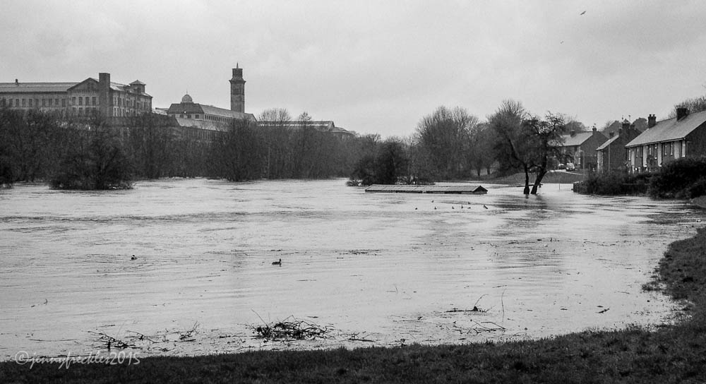
Saltaire has a new lake! This area is designed as a flood plain alongside the river, which normally flows between the trees on the left. It is used, I think, as a cricket pitch and you can just see the pavilion roof above the water. Normally those houses on the right are well above the river but they were beginning to flood and the residents were having to evacuate.
Monday, 28 December 2015

Baildon Bridge

At least the rabbit is prepared!

More flood pictures! It all has a compelling fascination - at once heartbreaking (when you see the flooded houses, businesses, damaged roads and bridges) and scary but also awesome to comprehend the power of the water and the scale of the floods. There were many people out with their phones. I didn't take my camera as it was so very wet.


This is Baildon Bridge over the River Aire just downstream from Saltaire. I was standing on a traffic island in the middle of the road.


The water was right up to the top of the arches...  river on the right, road on the left!


Green Lane, Baildon - not so green now!  Baildon Bridge (previous pics) passes across the photo between the buildings at the bottom of the road.


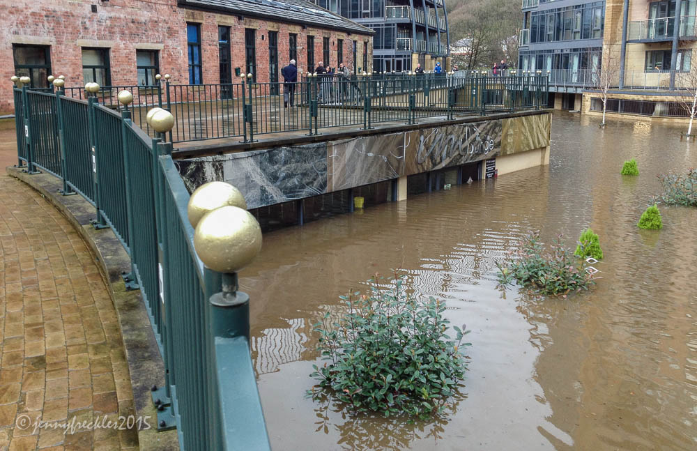
A family had to be rescued from the upper floor of one of these houses. In the background you can see the Victoria Mills apartment complex. That was inundated, though I think the lowest floors are mainly car-parking and service areas rather than residences. The picture below is in the centre of the VM complex and is a bar, the VM Lounge, flooded almost to the ceiling. The greenery is the tops of trees on the outdoor terrace.


Sunday, 27 December 2015

Boxing Day floods, Saltaire


There has been an unbelievable amount of rain since lunchtime on Christmas Day. River levels all over the north of England are surpassing their previous highest recorded levels. This is Roberts Park, Saltaire yesterday afternoon. The River Aire now reaches right across the cricket pitch and has flooded the Half Moon Café. (This is what it normally looks like.) I have never ever seen it anything like as bad as this.


The Boathouse Restaurant could now take in a boat again, just as in the old days!


The weir by the New Mill has disappeared apart from a wave. (It normally looks like this.)


The litter bins are submerged and in danger of being swept away. This is the path that goes under the footbridge.

Thankfully I got safely to my daughter's and back on Christmas Day so I had my Christmas dinner! (And delicious it was too, local farm turkey cooked to perfection in the Aga, well done my girl!)  It was a nasty drive back though, in driving rain and through lots of standing water on the roads. She lives above Hebden Bridge, which is now completely cut off by road and rail and the town centre is badly flooded. Thankfully, they had the field drains dug out above their house, so they have not (yet!) had a repeat of the flood in their home, though their neighbours were flooded again.

Later... 
The photos below were taken today (Sunday) at around 12 noon, about 24 hours later than those above. The water levels have dropped significantly, the rain has stopped and the sun came out so everything seems rather more cheerful - but there will be a lot of clearing up to do in communities all across the area.

My daughter tells me parts of the narrow lane to their house have been washed away down the hillside so they and their neighbours (about six houses) are marooned and cannot get vehicles out. They are currently involved in a community effort to patch it up so they can get out. But then, the road at the end of the lane has a landslide above and a massive flood at the bottom. Their town is still cut off, impassable by road or rail. Much clearing up yet to be done...  The water is causing huge problems as it moves further down the rivers too. The city centre of Leeds has been badly flooded and York is on high alert. Let us hope the rain stays away now to give us all a chance to regroup.